Cuba,
the largest of the Antilles, is an archipelago consisting
of a main island named Cuba, the Isle of Youth and about 4,195 keys
and islets. Its elongated and narrow shape propitiates circulation
of trade winds from the Atlantic, which cool its tropical, humid
climate. Only one fourth of the land is mountainous being its main
systems:
The Guaniguanico mountain range at the west region; the Sierra del
Escambray to the south centre of the country; and to the east the
Sierra Maestra with its Pico Real del Turquino, climbing to 1,974
meters above sea level, the island's highest point.The remaining
territory, plain and fertile, includes immense extensions of sugar
plantations (the island's main export line), tobacco (highly appreciated
worldwide) and other agricultural products.
The island's has more than 200 rivers of short course and flow impetuously,
which hinders navigation. The biggest river is the Cauto, east of
the country, with an extension of 250 km of which only 112 are navigable
by small crafts. Subsoil is rich in nickel and nature shows a variety
of plants and flowers as well as a marvellous diversity of animals.
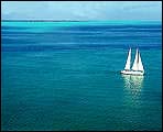
This Caribbean island has more than 280 charming beaches, virgin
keys, caverns and caves for exploration, as well as forests and
swamps for pleasure trips. Overall surface is 1 220 km.
Want to take a virtual tour of Cuba? Return to the home page and use our map navigator to visit over 70 Cities nationwide with photos, history, geography, famous people and much more!


 consisting
of a main island named Cuba, the Isle of Youth and about 4,195 keys
and islets. Its elongated and narrow shape propitiates circulation
of trade winds from the Atlantic, which cool its tropical, humid
climate. Only one fourth of the land is mountainous being its main
systems:
consisting
of a main island named Cuba, the Isle of Youth and about 4,195 keys
and islets. Its elongated and narrow shape propitiates circulation
of trade winds from the Atlantic, which cool its tropical, humid
climate. Only one fourth of the land is mountainous being its main
systems: 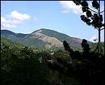 The island's has more than 200 rivers of short course and flow impetuously,
which hinders navigation. The biggest river is the Cauto, east of
the country, with an extension of 250 km of which only 112 are navigable
by small crafts. Subsoil is rich in nickel and nature shows a variety
of plants and flowers as well as a marvellous diversity of animals.
This Caribbean island has more than 280 charming beaches, virgin
keys, caverns and caves for exploration, as well as forests and
swamps for pleasure trips. Overall surface is 1 220 km.
The island's has more than 200 rivers of short course and flow impetuously,
which hinders navigation. The biggest river is the Cauto, east of
the country, with an extension of 250 km of which only 112 are navigable
by small crafts. Subsoil is rich in nickel and nature shows a variety
of plants and flowers as well as a marvellous diversity of animals.
This Caribbean island has more than 280 charming beaches, virgin
keys, caverns and caves for exploration, as well as forests and
swamps for pleasure trips. Overall surface is 1 220 km.